Tuesday, August 12, 2008

The Last Post

We have to share some difficult news...

On Thursday evening, August 7, 2008, Russell Towle, author of this blog, died after a tragic car accident on Interstate 80 near Sacramento.


Russell Towle Tribute Weekend
Dutch Flat, California, October 11-12, 2008.
More information, and some photos of Russell are here.


For those who didn't know Russ personally, or who only knew him in one context of his life, his family would like to share a little more about him with readers of this blog.

You already know he was an avid hiker in the Sierra river canyons near our home, and a tireless advocate for the preservation and development of public access to historic trails in the Sierras. Russell was also a brilliant and innovative mathematician, entranced by higher-dimensional forms. He was a computer animator. He was an extremely doting father who enjoyed every single moment of life with his kids. He was a lover of classical Latin literature and Shakespeare, of Tintin comics and Terry Pratchett novels. He was a historian and a writer; a geologist; a linguist; an artist; a builder; a musician with a special love of Brazilian music; a nature lover and photographer. He was a tireless trailblazer, who habitually carried loppers on his hikes, to trim the way and ease the passage of others who would follow.

Russ was self-taught; formal education processes were far too slow for his quick, deep, wide mind.

Follow the links at right to his Geometry blog, and to his YouTube videos. In the "Quintessence" video you can see and hear him talk about a favorite geometrical form in the setting of the small hexagonal cabin he built in 1975 and lived in ever after.

We are all SO blessed to have shared life with him, but no single one of us was really able to appreciate all of his gifts. However, all of us can appreciate the gift that he was able to give to the whole public, the gift that the readers of this blog are already familiar with. Below is a letter we received recently that explains just what we mean.

In love and tremendous grief, Gay, Janet, Greg, and all his family.


In the last two days I have reflected many hours on Russell and our friendship.

I have been hiking the North Fork of the American River canyon for over 55 years. Early on it never occurred to me to do any sort of trail maintenance, I just wanted to access remote fishing locations. Over twenty years ago I started to notice trail undergrowth cut back. First on the Green Valley traail, then the China trail, and the more remote locations like the canal trail between Euchre Bar and the Rawhide Mine. There was a unique trait associated to this work. The small trees and other undergrowth were not cut at ground level, but rather about knee height. One day I came upon a man sitting on a rock smoking a rolled cigarette. Propped against the tree next to him was a short handled compound lopper. He looked a bit rough, so I approached carefully. It was, of course, Russell, and we spent some time talking about the trail system that accesses the North Fork drainage. I was able to share some of my experiences and he seemed very interested. I do not remember telling him my last name or where I lived, however in a couple of days he called me at home.

We began to hike together and he very much impressed me with his absolute passion to protect and make available to future generations the historic trail system of the North Fork. He was literally a walking talking book on many subjects including local history, math, geology, plants, and wildlife. He shared this knowledge in person, in print and on the Internet for all to enjoy. I would learn more from him on one hike than all the books I could read in a year. I began to show him my special secret places like the railroad track in the sky mine. Watching Russell's excitement on discovering something new and unique in "his" canyon was one of my great pleasures.

Russell was determined about clearing trails like nobody I have ever seen. His energy was contagious and many like Ron, Catherine, and myself followed his lead. Sometimes the group was small and the job simple. Other times the group was large and logistics much more complex. I remember such a group clearing the trail from the Dorer Ranch to Sawtooth Ridge one late October day. This trail had not been in use for 75 years and was totally impassable. The operation included a raft to ferry people and supplies across the North Fork, multiple chainsaws, loppers, and one heck of a lot of effort over many hours. Russell was as always out in front directing the operation and the first one to reach the bear bed mine up on the ridge about dusk. He was delighted as only Russell can be about the day's success. It is interesting to note that the Hot Shots fighting the big July fire made use of this cleared trail. Russell also organized trash details to haul garbage left by miners out of the canyon. This was not a fun detail, but once again, following Russell's passionate lead, we filled our backpacks and hiked out. He was truly the custodian of our canyon.

Bodily, Russell is gone, however his spirit will forever remain in those he touched. When I hike the canyons and see the knee-high trademark of Russell's clearing, I will reflect on our long time friendship and his positive effect on the canyon complex and myself. It is said that you only come this way once, so make it count. Russell, our canyon custodian, made it count.

Steve Hunter
August 10, 2008

Saturday, August 2, 2008

After the Inferno: The Iowa Hill Canal


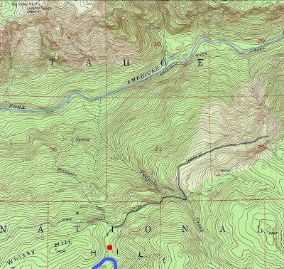
Above: Iowa Hill Canal Trail in grey, Foresthill Road, blue, parking, red.


Above: the Chinese Road


Early Friday morning I drove to Jerry Rein's remarkable solar home,
and we made the long odyssey across the American River Canyon to the Foresthill Divide, crossing the North Fork at Auburn, and then driving many miles to the northeast, past Foresthill, past Baker Ranch, past the sites of Forks House, and Westville, and Secret House, to the head of the Beacroft Trail.

We would visit the uppermost Iowa Hill Canal.

We parked amid more or less dense second-growth coniferous forest,
which had burned hot, let us say, here, and yet over there, a few
yards away, had not burned at all. I had seen, looking south from the
summit of Big Valley Bluff, that the fires had flared violently from
the river itself all the way to the top of the Beacroft Trail. I had
seen that the fire had, at least slightly, crossed the Divide to the
south. And I really thought I had seen that that huge, fire-spawned
brushfield along the Canal, east of Tadpole Canyon, had been erased in an inferno.

Well, appearances oft deceive. "Erased," as it developed, was far too
strong a term. One should not too-quickly pronounce the doom of those sturdy old shrubs of Green Manzanita, Bush Chinquapin, and Huckleberry Oak, those gnarled shrubs which had baffled many a bear for decades on end.

The Foresthill-Soda Springs Road goes back to 1852, when Placer County set out to provide a good route across the Sierra for the immigrants flooding into California from The States, i.e., Back East. "If We Build It, They Will Come," seemed to be the guiding premise of this project, called the Placer County Emigrant Road.

And "they" will spend their money here in Placer County!

The road crossed the Sierra crest at Squaw Valley, although I have
read that it forked above French Meadows, the northern branch entering the upper North Fork American near the Old Soda Springs, also crossing into Squaw Valley. The Placer Emigrant Road never came into use by the emigrants, other much easier routes, such as the road via South Lake Tahoe and Placerville, garnering all the traffic.

A mile or two beyond the head of the Mumford Bar Trail we began to see back-fires set by the firefighters along the north side of the road. Once again I was impressed, even astounded, by how expertly these fires had been managed. Not only were all the larger trees left unharmed, often even young conifers had survived these back-fires. Amazing, I think, that this could be achieved in July! Perhaps it was all done at night.

However, as we neared the low pass east of Whisky Hill where the
Beacroft Trail drops away into the great canyon, directly across from
Big Valley Bluff, we began to see more severely-burned areas. Never,
however, had the fire crossed the Foresthill Road, it seemed. That too was amazing.

The pass at the head of the Beacroft is full of archeology. There is
the trail itself; there is the massive Secret Canyon Ditch, which drew
water from the Middle Fork American side of the Divide, and delivered it, via a tunnel beneath the pass, to the Iowa Hill Canal itself: both ends of the tunnel are now collapsed; and there is a little road crossing the Divide and nearing east, to the beginning of the long flume section of the Canal, leading in and out of Tadpole Canyon, rife with cliffs and precipices.

I call this little road the Chinese Road, on the assumption that
Chinese labor was heavily involved in the construction of the Canal,
in the 1870s. I would guess that these Chinese workers had a camp in
the pass. There are two small basins which hold spring water, possibly intended for the teams of mules hauling the wagon-loads of sawed lumber to the giant flume under construction.

If one parks back to the south and walks in to where the Beacroft
Trail begins, but ignore it and follow a faint road bearing northeast,
one will pass the collapsed tunnel of the Secret Canyon Ditch, and
briefly the Chinese Road disappears. Blundering northeast into dense
forest, one will pick it up again easily enough.

It is this Chinese Road which forms the first part of the Iowa Hill
Canal Trail, as depicted on Tahoe National Forest maps of 1947 and
1962. It is now a long time since this trail has been maintained. Some
sections have been erased in rockslides and avalanches. With various
friends I have been working to restore the trail to a minimal
passability, over recent years. It is really one of the most scenic
and dramatic trails in our entire area. The bench cuts in the sheer
cliffs flanking Tadpole Canyon are quite incredible in and of
themselves. Beyond Tadpole is the Big Brush, and from that ancient
chaparral one gains an exceptional view of the canyon, Big Valley
Bluff, Sugar Pine Point, Cherry Point, and even Snow Mountain.

Jerry and I found that the dense forest along the Chinese Road had
been incinerated, only a few of the oldest Sugar Pines, three feet in
diameter, appearing to have survived with some foliage intact.
Everything smaller had become stark and blackened poles without any
needles or even smaller branches. The road was easier to follow. We
paused at a rock outcrop on the canyon rim for a good view north to
Big Valley Bluff, and observed the broad swaths of burned forest
leading from the river up to the cliffs of the Bluff.


Jerry spotted smoke rising from a blackened Douglas Fir trunk nearby; a rotten area within the trunk was still burning, the smoke escaping lazily from a hole in the trunk, fifty feet above the ground.

Continuing, we followed the Chinese Road as it crossed the Divide and struck more to the east, descending on a gentle grade towards the Canal, which began to appear below us, a truly gargantuan mining ditch.

Every step puffed up a cloud of dust and ashes. Many a rock had rolled
down onto the old road during and since the fire, and occasionally a
blackened trunk had leaned down across it. I lifted a few rocks to the
side and quickly my hands were blackened. My shoes and pants were
blackened. My arms and face were blackened. No human had walked in to the Canal before us, the ashy dust was pristine.

The bedrock here is the early-Paleozoic Shoo Fly Complex of metasedimentary rocks, but it is not often exposed, glacial till
covering much of the area, in a kind of "till shadow" extending down-ice from the higher ridges to the east, between Tadpole Canyon and New York Canyon.

Reaching the Canal, we followed it east towards Tadpole, almost immediately passing some stone walls which facilitated, in some way, the off-loading of the lumber. They were loading docks, as it were. These stone walls, made of carefully-stacked large boulders retrieved from blasting operations along the bench cuts ahead, had suffered some damage in the fire, many boulders showing fresh cracks from the intense heat, and one section having collapsed altogether.

Although the leaves had been scalded off the brush along the Canal,
the skeletons remained. I would say it was easier going than before,
except that very many boulders and rocks of all sizes had rolled down
onto the old Canal Trail. A few of these I moved aside, usually
placing them on the uphill side, so as to dam up the soil already
moving down the slope from above, and soon to descend by the ton, when the fall rains arrive.

Once we reached the precipices close to Tadpole Canyon, the intensity of the fire lessened, as there was much more rock, much less fuel, and whole stretches of the Canal were untouched. At the crossing of Tadpole Canyon tall patches of purple Fireweed were in full bloom. The stream is at a low flow, clear and sparkling through a succession of pools and waterfalls.

Crossing, we entered that little patch of tall conifers immediately to
the east, very badly burned, and then crossed unburned cliffy areas
for couple hundred yards before reaching the first outliers of the Big
Brush.

The Canal bears north before breaking out of Tadpole Canyon proper
into the main North Fork Canyon and the Big Brush. Here it changes
back from flume to ditch. It became apparent before we even reached that area that the Big Brush had by no means been burnt to the ground. Perhaps the only slight increase in passability is that the "outside-the-berm" path, a concession long long ago forced upon animals and humans alike by thick brush and trees growing from the crest of the ditch's high berm (for the most natural path would be on the berm crest)--the "outside-the-berm" path could now be walked rather easily. The bed of the Canal itself was also much more open than it had been, except it was so deep in soft fluffy ashes that to walk it was to nearly choke to death in clouds of ash-dust.

Soon we reached the edge of that ocean of heavy brush I call The Big
Brush. At exactly this point a faint trail forks away north, directly
down the canyon wall, with some very old blazes on trees just below
the Canal. These trees had been incinerated and only vestiges of their
foliage remained, near the tops, and even these had been cooked in the violent upslope winds of the fire, and left frozen, as it were, permanently bent as though that wind were an eternal and unvarying gale of great force.

I wished to explore down the old trail, always too choked with brush
to follow in years past, while Jerry wished to continue along the
Canal. I told him I would catch him up soon, expecting to take ten
minutes or so to scout the slopes below for this Mystery Trail,
depicted on the 1947 Tahoe National Forest map. It must have once led all the way down to the river, although the map showed it ending half-way down.

So I wound down the slope, picking my way through the skeletons of shrubs, seeing any number of possible trail segments, but no one continuous line presented itself. I scouted back and forth, to the west and to the east, as I dropped hundreds of feet in elevation. Seeing a nice promontory jutting into Tadpole Canyon below and to the west, I dropped down to it, and saw for the first time a waterfall I had often heard, easily a hundred feet high, in its upper, more visible part, and in full flow perhaps merging into a single two-hundred footer.

From the Promontory I broke back east on a contour and reached the faint ridge crest upon which I supposed the trail would most likely be found.

It was interesting to see, scant weeks since the area had burned, that
many of the bushes and small Black Oaks were stump-sprouting, fresh
green foliage pushing up through the grey ashes from the roots and
burls below. The Bush Chinquapin seemed the most eager to sprout,
while the burled Green Manzanita more rarely showed new growth. All in all, maybe one bush in one hundred is already showing new growth sprouting from the roots.

It was also interesting to see an occasional ant. And I saw some few
footprints from deer. As I scouted back and forth on the blackened
brushy slope, I began to see that the inimitable California Ground
Squirrel had at least sometimes survived the inferno, and fresh dirt
was piled outside their burrows, every two hundred yards or so.

Other than that it was a dreadful Desert of Death.

On my putative trail ridge I saw a faint and broad depression which
might have been an old prospect, although in the till blanketing the
area it was not clear what would motivate such a prospect. There were some small outcrops of bedrock nearby, at any rate. I saw no sign of any trail. Continuing on an eastward course, I soon saw some old cans scattered amid the burnt brush.

There were a few rusty condensed-milk cans, and a dozen or more larger cans of a curious construction. They were "double" cans, one can within another, a space of a quarter of an inch or so separating the inner from the outer, and on their bases were embossed these words:

TO HEAT CONTENTS
<--PUNCH HOLES-->
AT LEAST ONE INCH DEEP

Four dimples on the base marked where the holes were to be punched. Most all the cans had no such holes. Later, back at home, I Googled these double cans, and determined that in the space between inner and outer there would have been some quicklime, and a reservoir of water, which, when combined (by punching the holes to break the internal membrane separating the two), would react to heat the contents of the inner can.

This technology dates back at least to 1900, and quite a few patents
were issued over a period of decades. It was used by the U.S. Army in
WWII and in the Korean War for various types of field rations. Beyond
that, I could learn nothing.

That the cans showed up so close to the possible prospect made me
return west for another look at the latter. The second time around I
descried a faint trail leading right down the ridge. I followed it
down for a dozen yards or so until the blackened brush closed up too
tightly, and was left wondering whether it was or was not the Mystery
Trail.

Already four hundred feet below the Canal, I hesitated to drop any
lower. The sun was intense and there was no shelter at all. The few
trees were merely black poles casting thin stripes of shade. I
returned to the cans and cast around more widely, without finding
anything, and then struck east through a bad section of brush which
forced me into an intricate series of ups and downs and twists and
turns. A grove of conifers, all burned badly, lay ahead, and in
scanning these very slopes with binoculars from Big Valley Bluff, the
other day, it seemed an area which could have carried the Mystery
Trail.

However, although the burned grove contained any number of faint
terraces which a good imagination could conjure into a trail, there
was no tell-tale continuity which could settle the issue. Regretfully,
having exceeded my ten minutes by at least thirty more minutes, I
began a hot and dusty climb up through the Big Brush. Even in death
the Big Brush is formidable, and I found myself almost insensibly
pushed back to the faint ridge where I most-expected the Mystery Trail to be. This insensible pushing actually argues well for that ridge being the very line of the Mystery Trail. Sometimes one's feet are better arbiters, of such things as the courses of long-abandoned ancient trails, than one's brain or one's eyes.

Eventually I reached the Canal again, and followed it east. The sun
glared down and I didn't really want to push on through the glare and
the dust to the end of the Canal, almost a mile ahead, but fortunately I had delayed so long in searching for the Mystery Trail, that Jerry was already on the way back, and we met in the middle of that infinity of burned skeletons, and then turned back west and followed the good old Canal back to the Chinese Road, the pass, and the car.

Such was a very interesting day spent high on the walls of the
American River Canyon, within the area most-badly burned by the
"American River Complex" fire of June and July, 2008.

Monday, July 28, 2008

The North Fork Fire


Above: Looking south from Big Valley Bluff to Tadpole Canyon
Photo by Ron Gould

After weeks and weeks of smoke, the fires in and around the American River Canyon are mostly out. Today I joined Ron Gould for a visit to Big Valley Bluff, a grand eminence, the El Capitan of the North Fork, rising 3500 feet from the river, and near the eastern margins of the burned area.

We drove to Emigrant Gap, hung a right, and followed Forest Road 19 south, past the North Fork of the North Fork, past the East Fork of the North Fork of the North Fork, past Texas Hill, where we lost the pavement. Soon thereafter we began seeing evidence of the fire, which had encompassed an area of 20,000 acres.

Apparently Forest Road 19 had been used as a firebreak, and "backfires" had been set on the canyon side of the road. From
bulldozer scars I had seen miles away on Sawtooth Ridge and Humbug Ridge, I feared what I would find along the road to Big Valley Bluff. However, for the most part I was pleasantly surprised. The backfires, in particular, had mostly burned nice and cool, leaving all larger trees alive, and even most smaller trees.

The issue of bulldozer use on the fire has been complicated somewhat by what seems to be something in the way of what Tahoe National Forest terms a "hazard tree removal project," and various bulldozed paths radiated away from the road, and various piles of sawlogs were stacked along the road. There also seemed to be "staging areas" which had been bulldozed clear, here and there. Nothing seemed too extreme or heavy-handed, although I confess to a slow burn of hatred for bulldozers which has been building in my heart for many years. I begin to lament every square foot of forestland which is torn and trampled by the loud and stinking beasts.

Reaching the summit of the Bluff, we finally saw areas which had burned wildly, and it was impressive. In particular, the upper reaches of the Iowa Hill Canal, around Tadpole Canyon and the Beacroft Trail, had been hit hard. The Big Brush, an artifact of a fire decades ago, is gone. Erased. And large areas of forest nearby had been killed.

Also, a good two or three miles of forested canyon flanking the American River Trail had burned, and not in a cool, ground-creeping fire, but in an all-consuming crown fire.

It will be interesting to watch these parts of the canyon regenerate. I have little doubt but that much of the brush will stump-sprout, and by this time next summer there may be a froth of green over some of the burned area.

We hiked down to a certain slaty cliff-top, where I told Ron about the Fluttering Rocks.

It happens that if one is on a high-enough cliff with flat-enough rocks (a thin shard of slate is ideal), and if one throws the flat shard flat and spinning sharply like a Frisbee, far away from the cliff, so it will fall a long way ...

Then it will certainly happen that at first the shard will retain its horizontal orientation; and it will certainly happen that it will
gradually tilt to one side, and begin knifing steeply down in a vertical orientation, ever faster; and once in ten throws, I told Ron, it will happen that, as it knifes down, it will begin to flutter rapidly, a chaotic tumbling motion which beats the air in an audible, rhythmic, whipping susurration, and *it slows down.*

After a time I cast around for a shard of slate and found a perfect piece, three inches in diameter, nearly round in outline, and less than half an inch thick. I gave it a strong toss into the vastness of the canyon, where it could fall free for a thousand feet.

Sure enough, about six hundred feet down, it began fluttering, and slowed down. It is a marvelous thing to see.

While out at the Bluff we saw smoke from the big fire in Mariposa drifting north and seemingly crossing the Sierra crest right at the head of the North Fork. We also saw smoke from the fires farther north in a long white mass along the Coast Range up in Mendocino County. In fact, it was remarkably clear for a summer day, with fires still burning in many places; we could see Mt. Diablo, Mt. St. Helena, and Cobb Mountain, rising above the general line of the Coast Range, the Sutter Buttes, and even parts of the Sacramento Valley floor.

It was quite an interesting visit to Big Valley Bluff, one of the great scenic overlooks in California.

Monday, July 21, 2008

Birthday at Smarts Crossing


My son, Greg, turned seventeen over the weekend, and had a birthday party swim at Smarts Crossing. A merry group of nine young people and one old fogey made the mad drive down the rocky rutted road to a point well above the Bear River. We walked the last few hundred yards. Who can understand the antics of the Younger Generation; who can interpret their slang; who can fathom their music, if it can even be called "music." They vigorously debated an apparently age-old and perpetually captivating question, viz., whether ninjas or pirates would win in a flat-out fight, and made a series of sick jokes about zombie babies.

A monsoonal air mass had spread over the Sierra, and on the one day in the year when one could absolutely count on sun and blazing heat, it was cloudy and sometimes cool, with occasional showers dotting the dust. However, we were all inspired to swim the icy pool. A few of us made the jump from the Twenty-One-Foot Rock. The girls were sweet and lissome, the boys were, well, boisterous. At a certain point the boys thought it worthwhile to carry boulders to the Twenty-One, and topple them into the depths of the pool.

It was a good thing an old fuddy-duddy was present, inasmuch as hundred-pound boulders were deemed inadequate, and the young men were soon collaborating on two-hundred pound boulders, aiming to carry them up a slippery and sloping rock surface to reach the exalted Twenty-One. I had to intercede. One slip and it would be a broken leg, or arm, or foot, or hand. Later I just had to call a halt to the boulder-dropping altogether.

All in all it was a lot of fun to visit the great old swimming hole, enjoyed by generations of folk from Dutch Flat, and probably a favorite swimming and salmon-fishing spot for the native Californians of centuries and millenia past.

There are quite a few obnoxious metal signs nailed up by PG&E, warning of sudden releases of water into the river from Drum Powerhouse, and concluding with the order to "KEEP AWAY."

It is strange that PG&E ignored our beautiful Smarts Crossing for nearly a century, and that only now, in the 21st century, do they assert that the Bear River is no more than their own corporate canal, to be used exactly as they please, the rest of the world be damned.

We ignored the ugly signs. We need to find a way to put the private parcels along the old road into public ownership; Tahoe National Forest would be a good fit, inasmuch as the Crossing is already flanked by Forest parcels.

Thursday, July 10, 2008

Of Snakes and Squirrels

I live in an ecotone, a kind of blend between the coniferous forest of the Transition Zone, and the oak woodlands and savannahs of the Upper Sonoran Zone. The "life zones" of Merriam have fallen out of favor in recent decades, but I still find them very apt. Merriam recognized that, as elevation increases, in a mountain range, vegetation changes in very much the same way as if elevation remained constant, but latitude increased. To ascend the Sierra Nevada to the 5,000-foot contour and the realm of the White Fir is much the same as to go north into southern Canada. Merriam did his seminal research near Fort Valley, Arizona, where my grandfather Leland Towle worked as a forest ranger, at the time.

That was almost a century ago. Here, on Moody Ridge, in this ecotone between two different assemblages of vegetation, one sees two different assemblages of animals, also. For instance, both the Scrub Jay of lower elevations, and the Steller Jay of higher elevations, are here.

Today a young squirrel is slowly dying in my yard. It is a California
Ground Squirrel, Citellus beecheyi, and is more closely identified
with the Upper Sonoran life zone of the Scrub Jay, than with the
Transition life zone of the Steller Jay. And, since my yard is on the
cusp between the two zones, there are many Gray Squirrels in the area, as well. And Flying Squirrels, for that matter, although these are rarely seen.

The Ground Squirrel lives up to its name, only rarely venturing into
trees, and when it does, never climbing more than, oh, fifteen or
twenty feet. It will clamber into Ceanothus bushes and harvest the
seeds, storing them in cheek pouches, and then find some conspicuous
perch and slowly work through the seeds it has saved. It is strange
that they like these highly exposed perches, on a large boulder,
perhaps, for they are preyed upon by Golden Eagles.

It may be that another predator worries them much more than mere
eagles. The Western Rattlesnake, Crotalus viridus, is an avid hunter
of the Ground Squirrel. One might almost say, given ground squirrels,
rattlesnakes are sure to follow.

In this little clearing in the woods, in this ecotone, there has
always been a colony of ground squirrels, at least, for the
thirty-three years I have been here, there have been ground squirrels.
They fall victim to foxes, to bobcats, and, although one is extremely
unlikely to actually see it happen, to rattlesnakes.

This summer brought many a baby squirrel into the colony. The colony burrows are scattered over a broad area, and have multiple entrances, and may also be shared between individual squirrel families. It seems there are more squirrels now than ever before. One develops a sense of their lives and habits. I can recognize their metallic "alarm squeak," and sometimes, hearing the squeak, and taking a look around, I will see the fox, or the bobcat, which inspired that squeak.

The squeak is repeated, every second or so, for minutes, sometimes tens of minutes, at a time. It is painful to listen to this squeak. With a roar, and a hurled rock, I will sometimes try to quiet that squeak.

So. There are many squirrels, hence, as night must follow day, there must also be many rattlesnakes.

And there are. Four or five different snakes have visited the yard this summer. The hotter days seem to somehow inspire them to visit. Years ago, when my children were small, I killed rattlesnakes in the yard. In recent years I do not bother them. Live and let live. And yet ... and yet, they are so very hard to see if not moving, and they do not always rattle, and they coil up in places one can't really see well, anyway. It is a bit nerve-wracking. To have four or five different snakes visit, in one summer month, is a first in my several decades here.

I recently learned, on the Internet, that adult ground squirrels are immune to rattlesnake venom, and also, that they will wave their tails back and forth while facing a rattlesnake, and that the temperature of those waving tails increases by some five degrees at the time.

Yesterday I heard a doubled alarm squeak, in the sultry smoky heat of the afternoon, and walked slowly towards the sound, expecting to find a rattlesnake.

Sure enough.

An adult and a juvenile squirrel were atop one of their favorite Ceanothus-seed-eating perches, just above their burrow, both facing a spot a foot and a half away, and every two or three seconds, at exactly the same time, they would rapidly wave their tails, and squeak. It was as if they were telepathically connected. I could not see anything for them to squeak at, and slowly ventured closer.

The young squirrels are much more fearful of humans, than their parents, and they (there turned out to be a second juvenile, perched a few inches below) scampered away once I was within six or eight feet. The adult remained, steadfastly squeaking and waving its tail. Finally I saw the snake. It was occupying a crevice between two boulders, directly above one of the burrow entrances. The head and upper part of the snake's body were already coiled and still, the tail was extended away a foot or so, and was slowly being drawn into the coil.

I kept an eye on that snake as the afternoon dwindled into darkness. It never moved. I saw the adult squirrel enter the burrow, only a foot from the snake. The snake never moved. It seemed to be waiting for the squirrels to forget its presence.

At dawn I returned. The snake had gone. There seemed a peculiar lack of squirrels in the yard. This is common after a fox or bobcat visits.

An hour later I looked around again; an adult ground squirrel was on a large boulder, seemingly surveying its domain. And a few feet away, a juvenile was stretched out on the ground, its eyes open, alive, but hardly able to move. It had been bit by a rattlesnake in its right hindquarters, paralyzing its right hind leg. Over the next hour it painfully dragged itself twenty or thirty feet, downhill, towards one of its family burrows. The adult surveyed its child's progress. But then the venom's force overcame the young squirrel. It stopped moving. Its eyes closed. An hour later, it was dead.

There was absolutely no sign of the snake. All the squirrels entered their burrows and stayed within for hours, in mourning.

Sunday, July 6, 2008

Smarts Crossing

The number of historic public trails and roads which have been closed
to the public here in Placer County has grown too long to tell, at
least, in the course of such a count, it degenerates into a repetitive
whine: The Sky is Falling, and what's more, Life is Unfair.

Smarts Crossing is one of these historic public roads. A wagon road
led across the Bear River, from near Dutch Flat to the Liberty Hill
Mine, and Mule Springs, and Lowell Hill; once there was a bridge,
where an inner gorge holds a deep pool in its polished embrace ... one can still find the heavy iron pins set in the rock there, which
anchored the bridge, but some time, in the 1940s, the old bridge
washed way and was never replaced. On the Liberty Hill side, the road fell out of use and became overgrown; but on the Dutch Flat side, it was kept open, decade after decade, by local residents who loved to swim and dive in the long deep pool, and wander and explore up and down the river, and shiver while the hot canyon breezes swiftly dried the icy water from their bodies.

The Crossing derives its name from the Smart family of Dutch Flat, who once had a sawmill over on the Liberty Hill side.

As is usual, a complex of various parcels is crossed by the old road.
There are patches of Tahoe National Forest land in the canyon, around there, and also Bureau of Land Management lands: these are public lands. The road also crosses some PG&E land, land which I hope will become public land, as there is a settlement in the works, linked to the PG&E bankruptcy several years ago, a settlement which will transfer ownership of some thousands of acres of PG&E lands, to Tahoe National Forest.

And there is an ordinary private parcel, of some seventy acres,
through which the old road passes, on its way down to the sparkling
river. In the early 1980s, this parcel was sold, and the new owner was
quick to put up his "no trespassing" signs, quick to throw a gate
across the road, quick to turn people away at gunpoint.

Local residents banded together and filed a class action lawsuit in
the Superior Court in Auburn, maintaining that the Smarts Crossing
Road was a public road, and could not be closed. We could not have
done this without very substantial pro bono legal help, most notably
by Ed Stadum. We won our case. The road was re-opened. The seventy acres was sold, again, to a somewhat notorious real estate developer, which bodes no good, so far as continued public access to the glorious old swimming hole.

A few years ago, a second gate appeared on the road. A group of people at Smarts Crossing had been chased away by a sudden release of water from Drum Poerhouse, five miles up the canyon, and had complained to PG&E. Now, PG&E owns no part of Smarts Crossing itself; their lands lie rather high on the road, near its intersection with Drum Powerhouse Road. Nevertheless, PG&E decided that, in the interest of public safety, they would close the road.

Local residents complained about the closure, the gate, the sign, and
copies of the legal decision by the Superior Court were mailed to
PG&E's legal counsel. Eventually, in a show of compliance, PG&E went so far as to remove the lock. The gate remained, and it remained closed, but it was not locked.

This was not a welcome compromise, but at least public access was retained.

Recently I was informed that the PG&E gate boasted a brand new lock. Xanadu, for so I will style him, sent me a photograph of the lock. I am about paralyzed by anger and bitterness by all these closures of the historic trails and roads. I merely replied, to Xanadu, that, yes, it was indeed a lock. A large lock. My thoughts turned to an honored environmentalist of Dutch Flat, who advised me, years ago, to find a large pipe cutter, and trim the gate off at ground level.

Xanadu now informs me that, strangely, unaccountably, not only has the big lock disappeared, but the entire gate is gone!

Someone's heart is in the right place.

So far as the future, I regard it as essential that the PG&E lands near Smarts Crossing be transferred to Tahoe National Forest, and moreover, that the seventy acres which was involved in the original closure be purchased by Tahoe National Forest. The "recreational values" of that area (how I hate the language of the bureaucrats!) are too important to allow those lands to be given over to residential uses.

There are many many private parcels bordering Tahoe National Forest lands which must be purchased and merged with the Forest, IMHO. Some are entire sections, as at Four Horse Flat, on the Big Granite Trail, or at Wildcat Point, in the Royal Gorge. Some are tiny little parcels, once upon a time, who knows, patented mining claims. And some, as at Lost Camp, will likely require an Act of Congress, to adjust Forest boundaries.

And all this should be done without delay. I can't help but think that the hundreds of billions of dollars spent on our war in Iraq might have been put to much better purposes.

But that is just more whining.

Thursday, June 19, 2008

Letter to Tahoe National Forest

Below, a letter to Tahoe National Forest Supervisor Tom Quinn, urging him to take action to re-open the Lost Camp Road, restoring public access to the China Trail. If you wish, you can copy and paste the text below into an email to Supervisor Quinn, at pmahaffey@fs.fed.us, with whatever you might wish to add. The Tahoe needs to take its historic trails much more seriously.

*******
June 19, 2008

Tom Quinn
Forest Supervisor
Tahoe National Forest
631 Coyote Street
Nevada City, CA 95959

re: Lost Camp Road

Dear Supervisor Quinn,

In T16N, R11E the historic road to Lost Camp, giving access to Tahoe National Forest (TNF) lands, and to historic TNF trails, has been gated closed. The gate seems to be in the SE 1/4 of Section 14, the road continuing south into Section 23, which, being an odd-numbered section, one might expect would be one of the old "railroad" sections; but it contains a large patented mining claim (the "Lost Camp Mine"), and apparently was never deeded to the railroad. The Lost Camp Road passes through Section 23 into sections 26, 27, and 34.

Just north of the large patented claim in Section 23, in Section 14, a series of small parcels exist. The owners of these parcels have blocked the historic road with a gate.

The historic trails now blocked include the China Trail, constructed in 1862, leading from Lost Camp to Sawtooth Ridge, crossing the North Fork of the North Fork of the American River, and long maintained by TNF rangers; and the trail leading down the crest of the ridge dividing Blue Canyon from the North Fork of the North Fork of the American River to the Rawhide Mine. Yet other trails are affected by the owners of the small parcels in Section 14, mentioned above, notably, the Bradley & Gardner Ditch, or Placer County Canal, constructed in the 1850s to bring water to the hydraulic mines in Dutch Flat. This old mining ditch, although somewhat damaged by timber harvest activities, makes a wonderful trail, and has been used as such since its construction.

I should say that this is quite a remarkable area. The deep canyon of the North Fork of the North Fork American, and the river itself, are extraordinarily beautiful. If you look at a map, you will notice several tributary streams, all converging: Fulda Creek, Sailor Ravine, the East Fork of the North Fork of the North Fork, Burnett Canyon, and Willmont Ravine. All of these have fine waterfalls. I call this locus of convergence the Gorge of Many Gorges. It is just upstream from the crossing of the North Fork of the North Fork by the China Trail.

Most people, perhaps, who once used the China Trail, were fly fishermen. The tranquil beauty of the deep canyon, the sparkling clarity of the river, the cliffs and tall trees, and the trout, have brought hikers back year after year, decade after decade.

I wish Tahoe National Forest to meet its responsibilities and act quickly to re-open the Lost Camp Road and the China Trail. This road and this trail were among TNF's "system" roads and trails for many decades. This road and this trail are depicted on official TNF maps dating back at least to the 1930s, and are depicted on the General Land Office map of 1872.

The China Trail is a foot trail, despite the recent efforts of loud, lawless, garbage-strewing OHV users to convert it to a motorcycle highway. Since the OHV users have gone so far as to damage the historic China Trail, their use of the area must be curtailed entirely. There should be an OHV closure not only on the China Trail itself, but on the Lost Camp Road south of the railroad tracks.

When Tahoe National Forest was created, over a century ago, it inherited a fine system of trails, many dating back to the Gold Rush. The forest rangers faithfully maintained and blazed these old trails for many decades. For reasons beyond the scope of this letter, those trusty rangers of days gone by were replaced by people who wished to harvest timber, no matter what the cost to trails, to scenery, to recreation, to heritage resources, to wildlife.

That is, we went from a time when TNF actually protected its system of historic trails, to a time when TNF itself ruined many a trail, in the course of timber harvest activities. We went from a time when TNF would promptly intercede to keep one of its historic system trails open to the public, even where it crossed private property, to a time when TNF quietly, secretly, without any public comment, dropped historic roads and trails from its list of "system" roads and trails.

The Lost Camp Road and the China Trail must be re-opened and restored to the public, with an OHV closure on both road and trail.

Sincerely,

Russell Towle
P.O. Box 141
Dutch Flat, CA 95714
*******